
A new satellite-based assessment of India’s air quality reveals that Assam is rapidly becoming one of the country’s significant pollution hotspot, challenging long-held assumptions that the Northeast enjoys comparatively cleaner air. The findings highlight the growing need for comprehensive pollution monitoring beyond major metropolitan cities.
Experts emphasize that India’s air quality management must incorporate pollution data from rural, peri-urban, and smaller towns—not just large urban centers—to understand the full extent of public exposure. While ground sensors under the National Clean Air Programme (NCAP) and National Air Quality Monitoring Programme (NAMP) are expanding, they remain heavily concentrated in big cities, leaving crucial gaps in other regions.
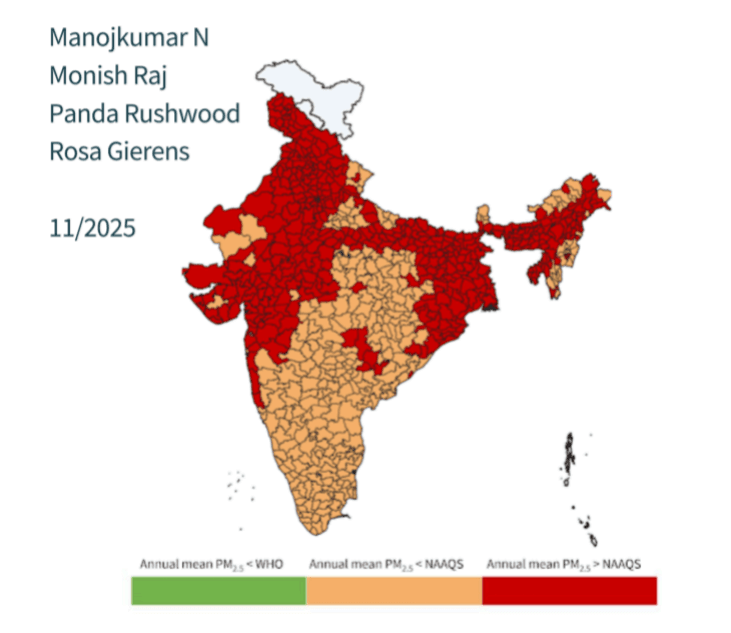
To bridge this gap, researchers relied on satellite-derived PM2.5 data generated through the advanced machine-learning framework developed by Kawano et al. (2025). These high-resolution, daily gridded pollution estimates were combined with population data from NASA SEDAC’s GPWv4 to calculate population-weighted PM2.5 levels across states, districts, and airsheds.
The results paint a worrying picture for India—and particularly for Assam.

Assam Identified as a Growing Pollution Hotspot
The assessment found that 11 districts from Assam ranked among the 50 most polluted in India, placing the state alongside traditionally high-pollution regions like Delhi, Haryana, and Bihar. Unlike most parts of the country where monsoon rains temporarily clean the air, the Assam–Tripura airshed remained polluted even during the monsoon season, indicating deep-rooted baseline emissions rather than weather-driven pollution.
The study also labelled the Northeast airshed as an emerging pollution cluster, second only to the heavily polluted Indo-Gangetic Plain. Assam and Tripura both recorded year-round elevated PM2.5 concentrations, with levels rebounding immediately after the monsoon.
Key National Findings Reinforce Assam’s Urgency
The satellite-driven analysis provides broader national insights that underscore Assam’s worrying trend:
- 60% of India’s 749 districts exceed the National Ambient Air Quality Standard (40 µg/m³) for annual PM2.5.
- Not a single district in India meets the WHO guideline of 5 µg/m³.
- Delhi remains the most polluted region, with PM2.5 levels 20 times the WHO limit.
- State averages often hide local hotspots—as seen in Maharashtra where 14 districts breach standards despite the state average being lower.
Airshed-Level Concern for the Northeast
While the Indo-Gangetic region remains India’s most polluted airshed, the Northeast—particularly Assam and Tripura—has emerged as a growing concern. These regions show persistent pollution levels throughout the year, underscoring that local emissions, not meteorology, drive the problem.
